•
October 2, 2025


Sand Technologies
In the chaotic aftermath of a hurricane, tornado, flood, or fire, one of the most daunting tasks is assessing the losses. Traditionally, reviewing storm damage has been a painstaking, manual process of going street by street and house by house. This task can take weeks, delaying critical aid and insurance claims. But what if it were possible to survey an entire disaster zone in a matter of hours?
Sand Technologies, working with Heavy.ai, leveraged AI and data analytics to demonstrate how city officials can quickly address the first challenge of storm response—accurately and efficiently quantifying the scale of damage. Using satellite and aerial images, paired with AI and large language models, the team assessed building damage block by block. By comparing pre- and post-tornado imagery, the model showed city leaders how to pinpoint the precise location of impacted structures and the extent of the damage.
Classifying tornado damage is essential. It helps government and civic leaders target the people most in need and calculate accurate damage totals. The model categorized structure damage by severity (from none to destroyed) and tied it to property values using historical parcel data. Categorization enables a precise and defensible estimate of the number of buildings damaged, with an associated cost of reinstating the buildings to their original state across the tornado path.
Returning to the tornado in St. Louis, the images below show the tornado path and damaged buildings, with both pre- and post-assessment images.
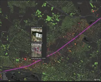
Image 1: Purple line shows tornado path
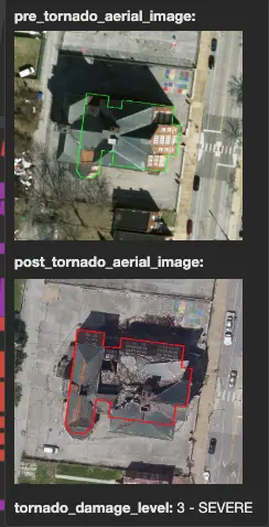
Figure 2: Before and after image
Using LLMs, the damage assessment intelligence was brought to life using interactive maps and resulting values. The maps overlaid the tornado’s path in purple with color-coded severity levels for every building. Detailed information such as this instantly shows leaders the neighborhoods hardest hit, the families most vulnerable (using the Social Vulnerability Index), and the cost of rebuilding. This level of clarity turned recovery planning from guesswork into action.
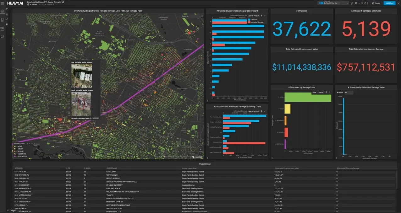
Figure 3: AI-generated storm insights dashboard
The intelligence data in Sand Technologies’ model shapes decisions at every level. AI-driven insights into storm damage create a powerful ripple effect across the recovery landscape, directly impacting the economy, resource management and charitable giving.
Beyond storm assessments, Sand Technologies’ AI-driven model can use damage category information to address another critical challenge: ensuring food security for displaced and vulnerable residents. Areas hardest hit can be quickly supported when the city optimizes its food distribution network—for example, transitioning from centralized distribution to a “hub and spoke” model to safeguard public health.
In 2024, there were 393 natural hazard-related disasters globally. Recovery from a natural disaster varies based on the severity of the disaster, the community’s specific challenges, the effectiveness of aid processes, and the ability of individuals to access resources. Time frames can take months to many years, or even decades.
Using AI models like the one described above starts the process of improving reaction times by drastically compressing the emergency response and planning stages for storm recovery, serving as a blueprint for the future of storm response. It is a powerful, real-world example of how any location experiencing natural disasters can adopt a new paradigm for crisis management.
In the face of overwhelming challenges, a powerful model has emerged: purpose-built innovation that meets the urgency of a critical moment, deploying AI solutions at a speed that traditional methods cannot match. It showcases how data can drive relief with precision, transforming ambiguous needs into actionable intelligence that directs resources to those most in need.
Other articles that may interest you